
Soviet Spies, Mozart Operas, Noël Coward’s Irreverent Drama, and The Eagles
July 1, 2026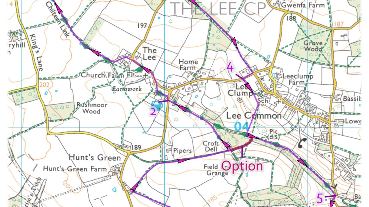
A stile free route on footpaths and tracks through fields and woodland, visiting the picturesque village green at The Lee.
Distance: 4.5 miles (allow 2½ hours) with a shorter 2.5 mile option (allow 1½ hours)
Start: Ballinger Common Recreation Ground, Blackthorne Lane, Ballinger HP16 9LN
Access Information: Easy walking with one moderate descent and climb. Stile free and numerous gates
Refreshments: The Cock and Rabbit at The Lee (longer option only)
Route
Cross the field to its right-hand corner, go through the gap and straight ahead along the field edge. In the next field bear half left to the right of the telegraph pole to the corner.
1 – Go through the gate, turn right and through the one ahead. Continue along the hedgerow and, where it ends, cross the field towards the right-hand side of a wood. Go through the gate, bear half right to the corner of the hedgerow, follow it round to the right and through the gate. Keep ahead along a wide track to a lane. (*For shorter option see below). Turn left up the slope and along the lane to The Cock and Rabbit Inn.
2 – Turn right then immediately left past the village green to a road junction and turn left. Walk along the road and, at the right-hand bend, keep straight ahead on a wide unsigned track to a major path junction. Turn right and follow signs for the Chiltern Way. Please note that this is a temporary diversion of the Chiltern Way to Waypoint 3. Continue ahead to the right of the hedgerow, stay in the same direction for 350m and ignore the path on the right. Stay ahead under the overhead cables, follow the field edge round to the left and turn immediately right through a large gap in the hedgerow. Continue along the edge of the next field for 170m to a major crossing path and turn right along The Chiltern Way.
3 – Cross over the middle of the field and through the gate on the other side. Turn right between wooden fences to reach a path junction in a wood. Go straight ahead to a wide surfaced track and follow it to a road. Cross the road and continue ahead on the path through the woods for 500m to reach a field. Fork right to the corner of the hedgerow and along its right-hand side. Go through the gate to a road, turn right past the village hall and shop and turn left through the kissing gate into the field.
4 – Follow the path between the fences, right then left and onwards through the gate ahead. Continue downhill and, just before the gate at the bottom, turn left and through the gate ahead. Follow the track to pass through a gate onto a road.
5 – Turn right for 50m, right again through a gap and follow the overhead cables uphill. At the top, pass through a gap and continue ahead to a road T-junction. Cross over and through the gate to finish the walk.
*Keep straight ahead for 170m to a T Junction. Turn right to rejoin the main route as described in the last sentence of Waypoint 4.
This walk was produced in partnership with The Chilterns National Landscape and updated in 2026.
